Posts

Showing posts from August, 2022

August 31, Loop into Pennsylvania and Blank Odometer

Image
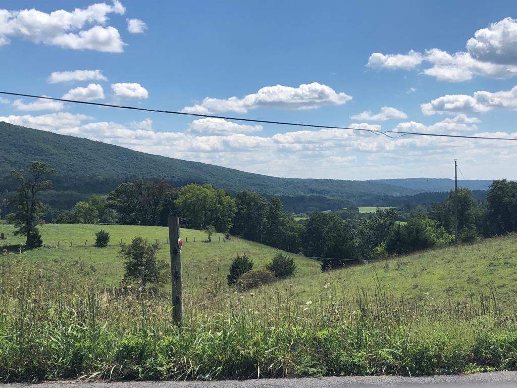
https://ridewithgps.com/trips/ 101562197   We have been looking at the last portion of our trip, and are thinking of traveling on Skyline Drive.  However, we didn't want to travel on it on the busy holiday weekend.  So we have  a couple extra days to spend before we go to Skyline. So we are staying an additional night at the Bike Bunkhouse. Tonight we have the place to ourselves (so far); the  rain drove in 5 other bicyclists yesterday who were all muddy and wet, and were eager for showers and a dry place to sleep. We asked at the bike shop if they had any suggested loops that weren't on the 2 trails and they did not, so we used our cycling apps and came up with a route that gave us about 2600 feet of climb which is good prep for Skyline.  We headed up a pleasant, rolling valley between 2 ridges, then we crossed over the ridge on our right and then a second one, then headed back toward Hancock.  We had perfect weather, beautiful views of ridges, woods and fields, saw a couple o

August 30. Another Flat and Bike Bunkhouse

Image
  Where we camped last night, the train track was on the West Virginia side of the Potomac.  Because we were at the point of a long peninsula on the Maryland side we could hear the trains for a long time as they went around the peninsula on the other side. From the shore of the river, you could just see the train in several spots through the trees.  Since we had seen trains that seemed abnormally long to us on earlier days, Kay counted the cars on a couple as best she could, one was well over two hundred and one was about 150.  We also saw the Amtrak train.     Today we got up to an eastern screech owl calling.  It was a nice morning but several days ago the weather report was for rain and the last we knew it would be starting sometime in the middle of the day.   We had something to eat and walked down the path to look at the Potomac, and it was about 8" lower than the night before!  This made us curious if we could wade across, as the river was quite wide there and the current wa

August 29. Lost and Found

Image
   Today we said goodby to our gracious host in Cumberland.  She has a foldable bike that she has taken to Europe and also traveled with it widely in the US.  We also heard her amazing story about when  she was scuba diving and had a large alligator swim up rapidly to her  and touch her flippers.  Just before this her diving companions had told her to freeze and not move, so she did. Then after what seemed like an eternity the large alligator drifted away.   She escorted us to the canal and we parted with hugs and a prayer. The towpath on the C & O canal is not  as smooth as most of the rail trails we have been on; it has a lot more ruts and stones. But it has the wild Potomac River on the one side about 2/3 of the time and on the other side is the canal, which sometimes has water in it and other places is dry with trees growing up in it. There are old locks and lock houses or their foundations  and occasionally an aquaduct.  We saw deer, many turtles sunnin

August 28 Hospitality and Being Regular Tourists

Image
https://ridewithgps.com/trips/101292315    Today we left our tent set up at our Warm Showers Host's house as she is letting us stay there for another night and rode our mainly unloaded bikes across Wills Creek and up the hill to St Paul's Lutheran Church which has been a body of believers since 1794.     The message was on being hospitable in spite of our differences. We have really sensed hospitality from the people we have met and in particular our Warm Shower hosts. As we started back down the hill, we started seeing historical signs about the old Fort Cumberland which had been located there on the hill and about George Washington's involvement with the fort. He started his military career there and ended it there when as Commander in Chief, he reviewed the troops come to put down the Whiskey Rebellion. That was the last time he put on a military uniform. We then found the 184.5 mile marker for the end of the C & O Canal.   The Allegany Mu

August 27 Milestones

Image
https://ridewithgps.com/trips/ 101189845 After returning to the campground last evening, there were some threatening clouds building up in the west.  We checked weather, and even though no rain had been predicted for yesterday, we got rained on for 20 minutes and now thunderstorms were predicted for the next hour or two.  We quickly moved our tent to the raised covered stage and sure enough started seeing some lightning.  So we were thankful to be under cover.   Today began with a series of 2 beeps right in a row every 5 to 10 minutes which started about 5:30. At first we thought that one of the other people in the campground were not turning off their alarm on their cell phone, or could it have been a nearby house where the battery was going bad on an alarm?   We went to breakfast at Donges, the same place we had supper.  One of a group of 4 on e-bikes were also camping came there too before the rest arrived. We found out that this man's 15-year-old grandson is diabetic and his al

August 26. ER for Bicycles

Image
We forgot to mention in yesterday's blog that, not including the miles from our family bike ride, we passed 4000 miles on this trip yesterday morning!     This morning, we got up at our usual time but between eating and talking with Kerry it was almost 9 before we left.  She shared with us her daughter's story about competing in Olympic cycling and then coming down with a never- diagnosed disease that caused a lot of tissue swelling, issues with her heart and made her extremely ill, and how they were consulting with all kinds of doctors. Kerry was stuck in Australia because of Covid, but eventually was able to join her.  After a period of time, her daugher spontaneously started feeling better and has been racing again.        Kayaks on the Yough in Ohiopyle State Park Our ride continued on through the large Ohiopyle Park for quite a while. We got lunch in Confluence which is where the Youghiogeny and Casselman Rivers and Laurel Hill Creek all come together. It had a

August 25, Two Waterfalls

Image
Today we rose to another morning with light fog, with the sun trying to pretend that it was the moon.  Later on in certain places as we rode along the trail, the sun shone between trees, creating sunbeams angling across the trail in the mist.   Last night we had heard about 2 waterfalls we would see today from a trail volunteer: the white waterfall, whose waters contaminated from aluminum production had stained the rocks white, and the red waterfall, where acid iron-laden water from an old coal mine stained the rocks red.   We ate breakfast about 10 miles away in West Newton where we had the 2 x 4 special:  two large pancakes, 2 pieces of toast, 2 eggs and 2 pieces of bacon. Last night, people at the campground had recommended this restaurant to us.  Although the trail became unpaved shortly after Pittsburgh, it it a smooth, wide surface of finely crushed limestone that is in great shape and easy to ride on.   We had great views of the river which go

August 24 Steel

Image
Last evening, Kay went outside and--is that a dog in the next-door neighbor's yard--no, a deer!  The doe then headed across the street with a fawn following, where they grazed on some bushes then headed across a corner.   One of our hosts used to work for a local NPR radio station and she now does freelance work as having two small twin boys takes a lot of time. We received directions for a route from our other host who used to ride his bicycle everywhere around town until an injury forced him to use a car more. We used his route to travel across about 5 miles of Pittsburgh, avoiding major hills, to return to the river valley. Here we crossed the Monongahela on the Hot Metal Bridge, called that as molten metal was transported across the bridge to be further processed on the other side. We were about 3 to 4 miles from the confluence of the two rivers to form the Ohio, so we rode back on the trail along the river most of the way to where we crossed yesterday to see th

August 23 Hills and twins

Image
https://ridewithgps.com/trips/100771950 We started the day similar to yesterday, a haze in the air and low-hanging clouds obscuring the top of the hills behind downtown.  A few blocks took us to the riverside and, after a bit of confusion as to which path on the waterfront to use, we headed north along the West Virginia side of the Ohio River. At one point we saw some huge silos between us and the river, and wondered what they contained.  They didn't appear likely to be grain silos, especially with an apparatus crossing to the top of them from the top of the bluff. Kay was just at the access drive when someone was driving out so she asked about them. They  turned out to contain coal. The mine was a mile away and the coal sent to the silos, from which barges were loaded from 6 am to 6 pm.  There was enough coal in the mine to last 25 years and it was already sold.   We came to where a new bridge was being constructed over the Ohio River. Due to the construction, the last

August 22 Landslide and West Virginia

Image
It rained a moderate amount late yesterday afternoon and early this  morning so we were glad for a roof over our head last night. Due to how places with lodging were spread out, we decided to just go as far as Wheeling, West Virginia.  This gave us a low-mileage day, which was good as there were scattered thunderstorms predicted for later today and tonight.  As we left this morning, it was cool but very humid with low-hanging clouds and almost foggy. Our route followed McMahon Creek for most of the day, which was brown and swollen from the rain. About 10 miles into our route, there was a sign that said the road was closed 6 miles down the road and had a detour sign.  We asked a driver of a pickup coming out of the road why the road was closed and if a bicycle could get through but he didn't know. then asked a homeowner out on his porch near the corner. He said there had been some sort of landslide causing closure of the road and thought a bicycle might be able to get through.  He a

August 21 Thunder, Tickling and Job

Image
Last night we stayed in a motel instead of a nearby state park because thunderstorms were predicted, with the potential of severe weather.  We are thankful we did as a thunderstorm with heavy rain arrived during the evening along with a severe thunderstorm warning.  We were in the lobby when the rain hit and someone who only lives 1 1/2 hours farther east came in to get a room as they were sick of driving in the heavy rain.  We also got more thunder and rain in the early morning hours. Since our daughter and family had planned a trip to the east coast and due to our route change that put us closer to their route, we had planned to meet up as they traveled.  They arrived during the night so today we got to share a meal and a short hike at the nearly state park. This was a "storybook trail" with a page of a book posted every so far along the trail.  Ironically, the book was "When the Storm Comes."   There was also tickle time and making rock buildings with

August 20, A lot of short hills in low gear

Image
https://ridewithgps.com/trips/100319018 Due to where hotels and campgrounds are located, we knew we wanted to go about 60 miles, a little more than we have been covering lately, and that the route would be hilly. Also the weather was supposed to be a little warmer than it has been. So we anticipated a little more challenging day. About 2 to 3 miles along, we turned on a quiet road and were out in the country. We saw some green arrows stuck on signs pointing people how to get to something.  Finally we found out what it was, an enduro motorcycle event, and passed several sections of the course. The country here in eastern Ohio is rolling and beautiful.  Several times the road on which we were traveling went along a ridge where the land fell away on each side with many beautiful vistas.    In Barnesville, we stopped at a corner in the shade of a building to take a break and eat a snack. The building was the office of a used car lot and the couple inside invited us in for a gla

August 19 Bridge Building and a Beautiful Rail Trail

Image
https://ridewithgps.com/trips/100319018 We had homemade breakfast sandwiches and pear slices at our hosts, so we were all fueled up fto begin our day.  The hills on the roads we took to leave were more fun than challenging, unlike on the way there!  A few miles away, we went by the largest Longaberger basket in the world!   Due to where lodging was located along our route and the mileage between what was available, we had a shorter day mileage-wise. So we decided to ride and hike at a park our hosts had mentioned. BlackHand Gorge State Nature Preserve has the Licking River and a beautiful 4 mile rail trail running through it and several hiking trails. A deep cut through the rock was made in 1851 to lay the tracks.   We saw a spider web lit up by the sun with multicolored shimmering. Each strand was visible, but in the photo a lot of the detail is lost.  It was about 10 feet off the ground and 8 to 10 feet between trees, so it was quite amazing that this spider w

Aug 18 try try again

Image
I have tried to post Aug 18 but it  was unreadable and have  tried various things to make it work, and accidentally deleted Aug 19 so computers and blogging is challenging us.   https://ridewithgps.com/trips/ 100209313 Last night, we fell asleep to the sound of a stream and to the noise of city traffic (the next-door neighbor had a small flowing fountain a few feet away, and the house was on US-23 as it went through town.) We were tired enough that we slept well.   We traveled a little north of Columbus before we headed east. We passed a huge manufacturing plant and then discovered that is a very large Budweiser plant. We stopped in a pancake house we passed and Kay tried the buckeye pancakes--had chocolate and Reeses chips baked in them and also melting on top. Our route took us through Inniswood Metro Gardens. We were amazed at the beauty and variety of plants and also at the many volunteers (our age or older) working on hands & knees weeding and caring for the gardens. 

August 17 Max and Larry

Image
https://ridewithgps.com/trips/100108505 Our Warm Showers host rode his bicycle from the west coast to Ohio back in 1981. When passing through Davenport, Iowa, he stopped at a grocery store and there were two puppies outside that he started petting as he had always dearly wanted a dog and his dad was a cat person.  Someone told him, "You want 'em?  Someone must have dropped them off here."  He scrounged around behind the store and found a banana box that he strapped on his bike and put one of the puppies in it. He took that 20+ pound yellow lab puppy all the way back to Ohio, about 600 miles. The comedy comes in that he would call his parents collect once weekly and he told them that he was riding with Max. They noticed that he wasn't traveling as far, but he didn't tell them about the extra weight and having trouble with broken spokes, he said that Max was new to cycling and he was getting him up to speed.  The next week he reported that he was still riding with M

August 16, 4 cranes & Cedarville wood frames

Image
https://ridewithgps.com/trips/100025215?privacy_code=PFX2v9BlqmTneCfr Our motel was right next to a truck stop so as we left, we got in line with 2 semis also leaving and had to wait while 3 other semis pulled into the truck stop. Once we made it across this busy intersection with I-70, we were able to turn on a quiet road that gradaully got farther away from the expressway and went over a covered bridge still being used that had been built in the late 1800s.   As we approached Lewisburg, we saw something being constructed about 1 to 2 miles south of town with 3 cranes like the ones used to build skyscrapers and an additional large crane on the ground.  When we stopped at a park in town, we saw a man walkng his dog, so we asked him about it . It is to be a Royal Canin pet food plant, the man said, and it has been under construction for over 2 years.   Our picture was taken from estimated 2 miles away.  As we came into Dayton, our route took us down a side path a

August 15 More trail riding and a great restaurant

Image
https://ridewithgps.com/trips/99884572 The weather still is pleasantly cool, and we had to wear long-sleeves or coats for the first few miles.  We headed back over to the Cardinal Greenway trail and headed south and east through Muncie and out into the countryside.  We saw 2 deer standing on the trail and got to within 20 yards before they scampered off the trail. The trail is paved and well maintained, the countryside is pleasant to look at and it gradually became more hilly. The trail was elected to the rail-trail hall of fame in 2018 and we can see why.   (notice under the road sign what is not allowed on the trail!) The trail ends at Richmond, Indiana, near the Ohio border.  We stopped to look up a restaurant and the Sip'n A Bite was just down the block but it closed at 2 and it was 1:56. We called to see if they would take last minute diners, and they said sure! it is fine to still come.  We had a good-tasting lunch of meat loaf & mashed potatoes with gravy, be

August 14 walk to church and a route change

We were pretty exhausted last night after a little bit higher mileage day and also due to arriving later than usual due to time for repairs, so we took today off to worship, take it easy, and catch up on things.  Shortly after the morning rain finished, we walked to a church about one and a half miles away. Oaks Church is part of a network of about 15 churches scattered around the country whose ministry focus is on planting churches and reaching people in university towns.  It was amazing to find out from their website that 41 people uprooted their lives and careers in 2015 to move about 75 miles to plant this church.  It was an upbeat service and the two of us were about the oldest or close to the oldest people worshipping. The teaching was from the first few verses of Second Timothy about being encouraging to others, having confidence about our faith and having courage in talking about Jesus.   We got lunch from a nearby Kroger and ate in our hotel room, then worked on routes part of

August 13, kicked out and cracked rim

Image
https://ridewithgps.com/trips/99692857 While we were at the pizzaria/ice cream shop,  an older teen on a small bike wearing a small backpack showed up and asked if we knew of a trucking company in town. We said we weren't local, so had no idea. He also inquired at the pizza place and in talking with them and us, he said that he had been kicked out of his house and was heading to a place to stay in Michigan just over the Indiana border. He said  that he had ridden his bike from south of Kokomo--on a bmx small bike with a damaged seat. The pizzaria owner got him some food. He said his muscles were very, very sore and painful so we encouraged him to take in some electrolytes and the food but this was hard as he was also nauseated. He asked us where we were staying and we said in a tent behind the pizzaria.  He asked if he could sleep on the ground next to our tent and we said yes, and the pizzaria owner went home and got a sleeping bag for him. After the pizzaria closed, we slept unde

Aug 12 Hawks, Woodpeckers & Denver

Image
https://ridewithgps.com/trips/99555154 Today we had another beautiful day for riding, nice humidity and it was cool enough that we needed long sleeves to begin the day.  Trying to get back to the route from the campground, we took what was supposed to be a paved road but it became gravel after 1 mile.  After about 3 miles on it, Kay especially was getting sick of it and had us head north and add a couple extra miles to pick up the route sooner.  We saw a lot of hawks during the first 15 miles, including 3 at once.  We also regularly saw red-headed woodpeckers. We crossed the Tippecanoe River today  but so did a lot of large semis heading to a huge landfill just a couple miles east of  Buffalo, IN. Once we were past it, the road became much, much quieter.   We crossed US 31 today, and a couple of miles east of that is when we were directly south of our home address in Holland.  The last part of today's ride was on the Nickel Plate Trail (a beautiful paved rail trail).   

Wed. Aug 11, Carolina Wren

Image
Since we began the day in a cottage on the Iroquois River, before and during breakfast we sat on a deck overlooking the river. There were a lot of birds singing, and we made a few sound recordings and found 9 different species of birds, not counting the mourning dove we occasionally heard.  Most special was a Carolina Wren which perched on a limb about 8 feet above us. It was smaller than many sparrows but yet had a very loud beautful song which it sang for quite a while while we watched and listened. A little later all the birds were making a big commotion. We looked around and there was a hawk perched in a nearby tree.  Today our route was mainly flat with a few gentle rolls (most of the country would call it flat).   Old "calaboose" (jail) in Iroquois, IL. Built because a new saloon was coming to town. In Brook, Indiana (notice we are now in a new state)  we got lunch from a convenience store and ate in a nearby park under a huge tulip tree.   We are camping in